These are the official maps of Game of Thrones, created for The Lands of Ice and Fire. They are canon – and the only maps to cover the east of Essos, including everything from Qarth to Asshai. They were created for Random House, from the hand drawn maps of George RR Martin,
In 2012 I was commissioned to illustrate the official maps of Westeros and Essos for the world of Game of Thrones. Each map is 3 feet by 2 feet in size, 72 square feet of maps in total.
If you’d like to know more about the process behind the maps, click through to read the articles. The maps are all © George RR Martin, 2012, used with permission
Warning – the last map contains spoilers as it shows the character journeys up to the end of A Dance With Dragons.
The Known World – The first entire map of Game of Thrones

The entire world map of Game of Thrones stretches past the Bone Mountains that divide Essos down the middle, over to the far East. Those distant lands include Asshai, in the Land under Shadow, with the mysterious and luminous ghost grass, as well as Carcosa, and Leng – both Lovecraft references that make it into Game of Thrones on the very edge of the world.
The details get sparser as you travel further east, not because of a lack of people – Yi Ti is replete with rich farmed land – but due to sparsity of knowledge. This map is created from the perspective of a Maester of Oldtown, and details on the far side of the world are filled in with more guesswork than perfect knowledge.
There are more details of the map, and description of how it was created, here.
The Free Cities of Braavos, Pentos, Myr and Lys

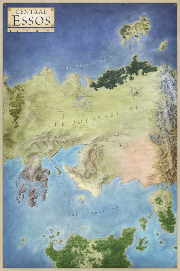
Map of Central Essos – including the Bone Mountains and the Red Waste
Map of North of the Wall – with all the Castles of the Night’s Watch

Slaver’s Bay – showing Meereen, Yunkai, and Astapor

The West – including the Narrow Sea, and the Summer Isles

The City of King’s Landing – from Flea Bottom, to the Red Keep

The East – with details of the Land Under Shadow, and Asshai

The Map of the Dothraki Sea and the Red Waste

Map of the Free City of Braavos

The Westeros Map – all the Castles and Kingdoms of Game of Thrones

Journeys – a map of the routes travelled by all characters
Spoilers – this last map shows the character paths to the end of A Dance With Dragons. Look away now if you don’t want to know the score.

Click on any of the maps for close up details and more information on how they were drawn. And you can pick up the posters here.

I bought these maps and they are great. However, they obviously are too cumbersome to look at unless you are at home. Will there be a digital version that can be zoomed in on via a tablet? Also would be nice if you could select whose journeys you wish to see and all others disappear.
As far as I know these will always be physical only. However, the full resolution files exist, so its possible that an app could be created in the future.
Do you know where I can find the full resolution files?
The full resolution files are © George RR Martin, and are in his and Random House’s hands. Only they have the rights to post the full resolution files. To see these in their full glory, you need to pick them up in a store. I’m afraid that’s the term of the contract for work like this!
Aamzings maps. Westeros, and his wolrd are very fascinating. And this word are wonderful, congratulations !
Unreal work! Very detailed and accurate! It’s amazing what you’ve done to help breathe life into my favorite fantasy world! Everyone I know who is a fan of ASOIAF wanted to see/own maps of Westeros and beyond while reading the series and now we can! Thank you so much!
Do you think you could release the set in book form? Great for a collection a much easier for reference when reading.
Not my call I’m afraid. That’s a Random House issue. I know that the World of Ice and Fire will be coming out later in the year, probably in time for Christmas, which might be closer to a true Atlas.
Is that possible to get a unfolded copy so that I can put it in the frame?
I’m afraid not. As far as I know, the only versions available are folded. I rather like the folds personally, as all the maps I grew up with were folded, and once it’s in a frame I don’t notice them.
Hi, I bought these maps and they are absolutely beautiful. Wonderful job. Any possibility of getting the Tolkien publishers to have you do a map set like this for Middle Earth?
Thanks a lot. I’m so glad you’re enjoying them! Unfortunately I think that Middle Earth maps are pretty much sewn up 🙂 But I’d definitely say yes if they asked.
Too bad they’re not available digitally and zoom-able ( without having to download them for the copyright reasons you mentioned ). I mean, I am obviously a GoT reader and would love to have a closer look at the places G.R.R. Martins mention in his books without buying having a poster that would be hard to find anyway.. They look absolutely stunning by the way, you did such a great job really !
You can get a closer look of some of these in the official Ice and Fire app from Random House. But otherwise, it’s a Barnes and Noble trip (or Amazon).
Glad you like them!
Would be funny if there was a Google Streetview version…I can just imagine the car getting jumped at The Twins and stabbed in the eye a few times – with regards from the Lannisters, of course… 😉
Some crazy people have taken a lot of this and mapped it in Minecraft. So Streetview isn’t actually that farfetched!
Having been “Streetviewed” about a month back (I saw the car go and I wondered if they’d get me, as I was sitting in the shadows waiting for my ride to come and they sure did! Blurred my face, but anyone who knows me would certainly recognize my “boonie hat.” 😉
Seems to me the full map is still incomplete, but maybe that is by design since there are still two books left. Will there be further updates?
The map is of the known world, rather than the full globe. The world map should be current for all the books to the end – but the map of Journeys will be outdated once the series continues.
So more dragons could still exist outside the known lands. 🙂
It’s a big world 🙂
@Kent, Pauline Baynes (RIP) did a splendid map poster of Middle Earth which I owned at one time. Try eBay.
And, Jon, wonderful maps! Thank you!
You’re welcome! And good call on the Pauline Baynes map.
No you didn’t! Whaaaat? I am a HUGE fan of A Song of Ice and Fire! That was you???? Consider me a whorshiper from now on.
Do you watch the show? Read the books?
Of course I do! I read them around 2000/2001 initially, then again around 2008. I had to get Storm of Swords on audiobook so I could catch up whilst illustrating these.
interesante, muy original
Can I ask a little question?
Do you know why the Hidden Sea is darker than other inland seas of the world? Is it because it’s deeper or just artistic preference?
And why is Sea of Sighs is pinkish?
Please answer these if you have information regarding them.
Thank you!
It was clearly communicated to me that they should be, but not why. Sorry!
I finally just bought these for my husband for our one year anniversary and I absolutely cannot wait for them to get here!! I bought these as much for myself as I did for him 🙂 haha! Fantastic work, I’m fascinated!
I hope you love them!
i love theses i have them the only problem is there is no scale, for war games purposes. i have no clue how far anything is
You’ll find no maps have scales on for these lands. That’s intentional. But if you take the wall as 300 miles, that’s a good start.
Another good scale is the distance from Yunkai to Meereen. Daenerys goes past 163 mileposts along the road, so the distance is 163 miles.
Does anyone else notice that Westeros and The Eastern Kingdoms (in Azeroth) are very similar?
Hey Jon, do you do any freelance work?
I do – but pretty busy just now.
That’s understandable, I wont take up too much of your time, im looking to see if you would be interested in gameboard map design. If you have some time to chat about it let me know. Thanks!!
Hi, I am curious how kept the proportions same for all the different maps.
I am in the process of digitalising my own maps for an rpg campaign I am making, and I want to have one World Map as well as several local maps. I want to have the proportions and scales on the local maps as accurate as possible to the world map. I noticed you were able to keep the coastlines and the general geography true to the world map in the local ones.
At the moment I have landed on using vectors as guidelines for the different maps, but I am no photoshop pro and would love to learn how you did it with these maps.
Hey Jon,
Any chance on you making any map makers for the book characters? I know Dark Horse has made some but they only cover the houses in Westeros and not all of them. May be a good market for this considering it would be fun to reread the books and move the markers around these maps while reading.
markers*
I’ve just got these maps and they are amazing. If you sent the OS map guys to Westeros they couldn’t have done a better job. Thanks so much for making them.
Hi Jon, these maps are amazing!
I don’t know if you monitor these comments anymore, but thought I’d let you know… For the “A World of Ice and Fire” Android app, the map of “The Known World” has a typo, with “The Milkwater” spelt as “The Milkwaer” instead.
Ha, thanks! That typo must have been there from the start. There’s so many labels…
Congratulations for this! I know it took them a lot of effort just to make an extensive map just like this one. It is really a job well done and it looks great too! My dad is a huge fan of game of thrones as well as my boyfriend. I hope these are available in the market for it would be a perfect gift and a collectible for them.
Hi there. I was wondering if it would be okay to use the images of essos, ulthos and sothoryos for a youtube video I hope to make. Would it be okay to use these images?
I’m afraid not – GRRM owns the copyright to these.
Your work is awesome! Using this all for some inspiration and tips for my current map project.
Are “The West”, “The East” and “Central Essos” the same scale, relative to each other?
Roughly. The East and Central Essos are at the same scale. The West is a slightly different scale to fit to the map better. So you can’t quite line these up side by side to one big map.